Dolphin Preliminary Movement Patterns
Preliminary Movement Patterns for Western North Atlantic Dolphinfish
(Published May 2010)
Studying the movements of fish requires that a large number of individuals to be tagged and recovered to define normal travel for the species. When the fish is a highly migratory species known to occur over vast areas of an ocean, then animals need to be tagged throughout its known range to get a comprehensive understanding of the routes used and to establish the relationship between widely separated groups. Understanding movement patterns is critical to fishery managers in their efforts to properly manage a stock of fish.
The Dolphin Tagging Study began in 2002 as a tagging effort off South Carolina. As the breadth of the movements by East Coast dolphinfish began to materialize, the program quickly grew to encompass the dolphin's range throughout the Western North Atlantic Ocean. The program has been extremely successful, having more than 11,000 fish marked with the majority released along the U.S. Atlantic coast. Tagging activity has not been uniformly distributed along the East Coast. More than 60 percent of the fish tagged have been off south Florida and its Keys, Stuart to Key West. The second largest proportion of tags, 22 percent, has been deployed off South Carolina. Anglers in Bahamian waters have generated the third highest proportion of dolphin tagged, 8 percent. The majority of the 350-plus tag recoveries have come from fish tagged in these three areas, allowing for the first look at dolphin dispersal patterns from these locations.
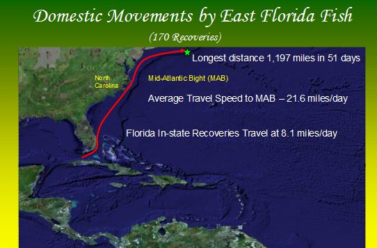
|
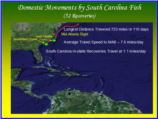   |
- Dolphin tagged off the U.S. Atlantic coast have shown up throughout the Caribbean Sea, being caught off Cuba, Puerto Rico, St. Kitts, Antigua, Venezuela, and Mexico at the Belize border.
- The most distant recovery report came from the eastern North Atlantic where a Spanish commercial fishing vessel recaptured a tagged fish off the Azores Islands. The fish, released off Charleston, South Carolina, had traveled a straight line distance of 2,500 miles during its eight months of liberty.
- These recoveries suggest the existence of migration routes that carry some portion of the U.S. East Coast stock throughout the Caribbean Sea while others may travel into the eastern North Atlantic.
- Recaptures have shown dolphin continually move northward along the U.S. Atlantic coast riding the ocean currents, disappearing for varying time periods before showing up in warm tropical regions.
- East Coast fish tagged one year and recovered the following winter or spring in the Caribbean Sea or distant areas of the North Atlantic Ocean suggest the existence of multiple routes that dolphin use to move south during the cold months.
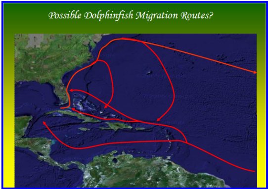
- Some fish may make a circum-Atlantic migration that encompasses 8,000 miles or more. Such travel would only require an average daily movement of 22 miles.
- Fish may exit the Gulf Stream off Cape Hatteras, North Carolina, traveling southeast to catch a southerly counter-current that will carry them to warmer southern waters.
- Those fish that travel to the Atlantis Canyon area off Montauk, New York, could turn southeast, traveling beyond the island of Bermuda before catching a southerly current back to the tropics.
- Dolphin probably use numerous routes based on primary ocean currents as well as intermittent currents that carry them east and south on their return to the tropics.
Summary
While dolphin are caught off the southeastern U.S. coast throughout the year, there is a definite seasonal occurrence. Data indicate that the majority of these highly migratory fish are constantly moving northward along the U.S. Atlantic coast regardless of season. Dolphin begin increasing in numbers in the Straits of Florida off the Keys in late March and April, building in numbers into late May or June when they normally peak in abundance. Off South Carolina, dolphin typically reach their peak abundance from May to early June. Peak abundance off North Carolina commonly occurs in June, while the peak abundance in the Mid Atlantic Bight normally occurs from late July to early September.
These fish are entering the Straits of Florida from the west by way of the Loop Current in the Gulf of Mexico and from the east traveling the Old Bahamas Channel. These fish move northward along the east coast of Florida where heavy fishing pressure on the western side of the Stream harvests a large proportion of the fish. This fishing activity appears to push surviving fish to the eastern side of the Gulf Stream where they remain as they travel northward to North Carolina and the Mid-Atlantic Bight.
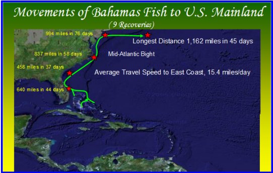
Dolphin moving northward from the Straits of Florida are joined by fish traveling from the eastern side of the Bahamas Bank. Rounding the northern tip of the Bahamas Bank, eastern Bahamas fish begin entering and even crossing to the western side of the Gulf Stream at a point east of Fort Pierce Inlet, Florida. Fish from the eastern Bahamas serve to replenish the dolphin stock on the western side of the Gulf Stream for their northward journey along the U.S. Atlantic coast. Fish coming out of the Bahamas could be the primary source for dolphin caught off the Carolinas.
Fish tagged off South Carolina on the western side of the Gulf Stream have exhibited a much slower rate of northward travel than their Florida counterparts. The reason may be the presence of two intermittent gyres found on the western wall of the Gulf Stream off the Carolinas. Dolphin could enter these large rotating water masses and swim in circles for days, weeks or even months before exiting to continue their northward trek. Fish moving up the eastern side of the Stream would by-pass these obstacles and not be slowed in their northward movement.
It is off North Carolina that dolphin coming out of Florida are once again caught in large numbers by recreational anglers, likely because the Gulf Stream comes much closer to landfall in this area. It is unknown what portion of the dolphin population departing North Carolina continues northward into the Mid-Atlantic Bight and what segment turns more eastward, moving out into the open North Atlantic.
Dolphin probably use a large number of routes to move south when they depart the U.S. territorial waters. These routes could be as long as a circum-North Atlantic trek or as short as a circle around the Grand Bahamas Bank. The route chosen will likely involve an ocean current that helps them along, even if it is only an intermittent current, and it will likely contain a good abundance of baitfish to sustain them. Dolphin tagged off the U.S. East Coast have traveled to South of the Azores Islands in the Eastern North Atlantic, Puerto Rico, Antigua, St. Kitts, Venezuela, Mexico and Cuba. Such widely dispersed recoveries question the validity of a three-stock theory currently held by fishery managers for dolphinfish in the Western Central North Atlantic Ocean.
Recoveries have also shown that dolphin will return to U.S. territorial waters. Such return visits have occurred within the same year, but most have spanned a winter. Typically, the fish is tagged during the spring or summer of one year and recovered in the next year. This does open the possibility that if fishermen release more small fish, they could be rewarded the next year with more big fish.
By Donald l. Hammond, Director, Dolphinfish Research Program, Charleston, South Carolina
NOTE: Article prepared May 2010. Information presented here is based on a dynamic data base that is continually being updated, which can lead to new information altering our understanding of dolphinfish movements.